


Hiking tips for Gohrisch and the surrounding area
A well-marked network of hiking trails caters to a variety of needs. Easy, mostly flat hiking trails equipped with benches and rest areas lead to interesting vantage points. The seven climate trails around the spa town of Gohrisch are particularly worth mentioning. Three nature trails provide information about the natural and cultural landscape. In the district of Cunnersdorf, the forest pool invites you to cool off and relax in summer.
On your hikes through the municipality, you can enjoy small highlights such as the fire department museum in Papstdorf and the lapidarium in the spa town of Gohrisch.
Hiking destinations
Boundary stone – Lapidarium in the spa town of Gohrisch
You often stumble across forest boundary stones and land boundary stones, but you never know exactly what the swords, crowns, and numbers mean. In this forest boundary stone exhibition and land boundary stone exhibition, all the symbols are explained, leaving no questions unanswered in this regard for the future. The exhibition is located at Sandweg 43b.
Insider tip for hikers!
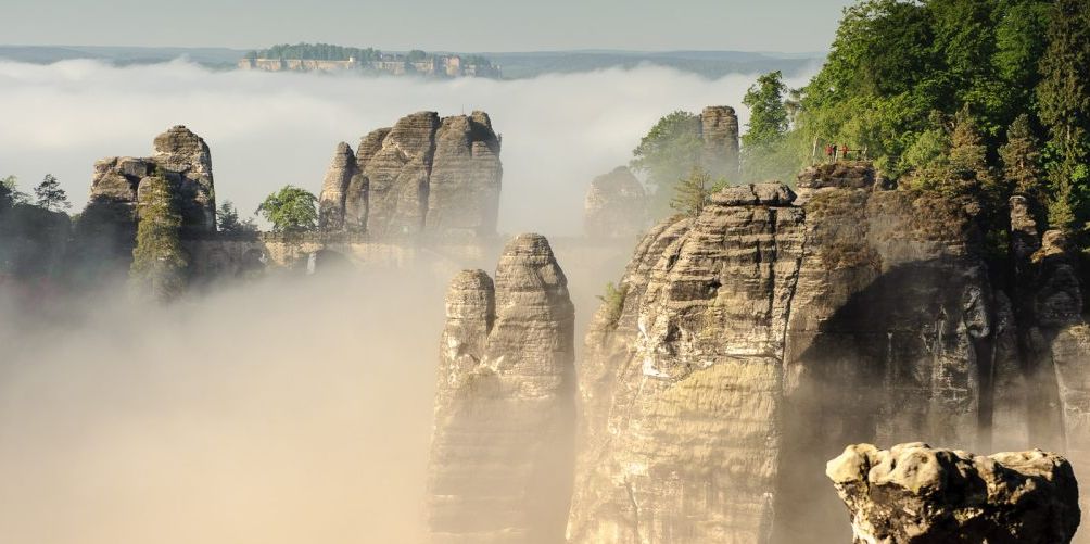
The municipality of Gohrisch maintains a parking lot in Kleinhennersdorf at the entrance to the village (Alter Schulweg). It is not very busy, even during the high season, and offers numerous hiking opportunities in the area around Papstdorf and Kleinhennersdorf (Papststein with mountain inn, Gohrisch-Stein, Kleinhennersdorfer Stein, Kohlborn- and Lasensteine). In any case, the area is well suited for a hike with beautiful viewpoints.
Dam wildlife enclosure
The wildlife enclosure is located between Papststein and Kleinhennersdorfer Stein. At the edge of the enclosure is the small wooden forest railway “Berndi,” which is extremely popular with younger visitors. The hike goes to the left between the enclosure and the forest. The hiking trail is marked with a red line. At the end of the enclosure, you can enjoy the view of the Schrammsteine and the village of Kleinhennersdorf.
Rockfall at Papststein
From Hans-Förster-Weg, you can see huge sandstone blocks that fell into the valley during a rockfall in January 1972.
Caves at Kleinhennersdorfer Stein
The largest cave at Kleinhennersdorfer Stein is the Lichterhöhle (Light Cave). It was named after the candles set up by mountaineers during celebrations. The cave is 20 m long and 15 m wide and was used for sandstone extraction. The neighboring cave, the Sand-Hampel-Höhle, was named after Friedrich Herrmann Hempel from Königstein, who started sand mining here.
Guided hike to the Kleinhennersdorf caves:
Every Wednesday from May to October, meeting point: 10:00 a.m. at the “Zur Hoffnung” inn in Papstdorf
(exact dates under Events)
Short hikes around Gohrisch
1. Circular route
(easy route, 6 km, walking time approx. 2 hours, 90 meters of elevation gain and loss)
From the Gohrisch municipal administration office, head towards Papstdorf until you reach the junction with the road to Bad Schandau. Turn right here into the “Stillen Grund” valley. After 700 meters, turn right again. At the edge of the forest, follow the “Jagdsteig” and then the ‘Königsweg’ to “Pfaffendorfer Straße.” Cross this to the left and follow the old school path to the “Schöne Aussicht” with a view of Königstein. Return to the Gohrisch spa resort and municipal administration office via the circular route.
The entire route is marked with yellow dots.
2. Papststein Gohrisch (rock)
(moderately difficult route, 6 km, walking time 2 hours 15 minutes, 290 meters of elevation gain and loss)
Take the road from the municipal administration office towards Bad Schandau. At the end of the village, leave the road on the right and continue on the “Alte und Neue Jäke.” After about 200 m, keep left at the “Jäke” junction until you reach Suppelsgrund. Walk uphill to the saddle between Kleinhennersdorfer Stein and Papststein.
Now follow the red dot markings to the right and climb up to Papststein (452 m above sea level) (restaurant). Take the west descent (red dot) to the parking lot at Papststein. Cross this and take the unmarked path past the Specksteinstollen tunnel up to Gohrisch (448 m above sea level). There are two options for the descent on the west side: either the romantic but somewhat more difficult path through the Falkenschlucht gorge or the easier west descent. Both paths meet again at the foot of the rocks. From here, continue down the stairs to the Muselweg trail. Follow this to the right, following the yellow line markings, back to the spa town of Gohrisch.
3. Pfaffenstein
(moderately difficult route, 9 km, walking time approx. 3 hours, 290 meters of elevation gain and loss)
From the municipal administration building, take the road toward Pfaffendorf until you reach the intersection with the “Muselweg” hiking trail. Turn left here, follow the yellow line markings across the fields to the edge of the forest and continue for another 200 m to the “Cunnersdorfer Steig” junction. Turn right here and walk to the road to Cunnersdorf. Now follow the red dot markings, initially downhill, then soon uphill again, to the old ascent of the Pfaffenstein. Climb this to the plateau (427 m above sea level). From the restaurant, be sure to walk to the southern tip to see the Barbarine rock needle. The descent is through the steep needle eye and on to the parking lot. Then walk up the village road and after 200 m turn left to the spa town of Gohrisch.
4. Königstein Fortress
(easy route, 14 km, walking time approx. 4 hours 40 minutes, 416 meters of elevation gain and loss)
From the municipal administration building, take the road towards Pfaffendorf until you reach the junction with Pladerbergstraße on the right-hand side. Follow this road, keeping to the yellow dot markings, to the “Schöne Aussicht” (beautiful view) (view of Königstein). Now descend to Königstein on the green line. From the post mile column, follow the same markings to “Reißiger Platz.” Now follow the blue line past the former restaurant “Palmschänke” to the fortress (365 m above sea level). Descend following the red dot markings to “Reißiger Platz” (don’t miss the turnoff just below the wall). Follow the yellow line along Bahnhofstraße, which you leave on the right at its highest point, and begin the ascent to the spa town of Gohrisch.
5. Lilienstein
(moderately difficult route, 13 km, walking time approx. 4.5 hours, 470 meters of elevation gain and loss)
From the municipal administration building, take the road towards Pfaffendorf until you reach the junction with Pladerbergstraße on the right-hand side. Follow this road, keeping to the yellow dot markings, to the “Schöne Aussicht” (beautiful view) (view of Königstein). Now descend to Königstein on the green line. From the post mile column, follow the same markings to “Reißiger Platz.” Now follow the blue line towards the Elbe to the ferry. After crossing, follow the same markings via the south ascent to Lilienstein. The descent is via the northern descent, which is also marked with the blue line. Immediately at the foot of Lilienstein, turn right and follow the unmarked path back to Königstein. After crossing with the ferry, follow the yellow line along Bahnhofstraße, which you leave at its highest point, along Pladerberg to the spa town of Gohrisch.